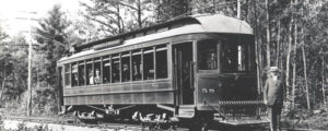
Atlantic Shore Railway #58 in Wells, Maine
The Atlantic Shore Line (ASL) was the local electric trolley line providing passenger and freight service to many York County towns. The ASL was the second longest trolley line in Maine, encompassing over 87 miles of track. ASL statistics provide information dealing with the impact that the ASL had in developing York County’s social and economic structure in the early 20th century. As an example, during 1907, the ASL carried nearly five million passengers. At its height, the coal traffic on the ASL totaled 50,000 tons annually.
The expansion of the line over the years resulted in residential and commercial development in the surrounding areas, providing a variety of employment opportunities for the local population.
From the Town House Square carbarn in Kennebunkport (the site currently across the street from the Kennebunkport Historical Society), ASL trolley service connected Cape Porpoise, Kennebunkport, Biddeford, Kennebunk, Alfred, Sanford, Springvale, Wells, Ogunquit, York, York Beach, Kittery, Eliot and South Berwick, Maine. The line also connected with Dover, NH through South Berwick and with Portsmouth, NH via ferry service from Kittery (the ASL ferry “Kittery” was built in Kennebunkport in 1900).
Four miles of the ASL right of way between Town House Square and Biddeford off of Log Cabin Road in Kennebunkport has been preserved by the Seashore Trolley Museum. The Museum has developed its demonstration railway upon two miles of the old right of way.
Documents on the Atlantic Shore Line
New Traffic Artery. Steel Path Which Electric Road Builders are Blazing to the Seaboard. The Trip by Trolley From Sanford, Past Old Falls on the Mousam to Kennebunk. (Sept. 18, 1899)
By Trolley To Sanford. The Trip Over the New Road From the Kennebunk Town Hall
Hits Drummers’ Fancy and Sunday on the Electrics (1899)
A Step Back into the Atlantic Shore’s History (2007)
Quick Facts on the Atlantic Shore Line
Incorporated:
February 9, 1900
Purpose:
To build a trolley line from Biddeford to York Beach via Kennebunkport, Kennebunk and Wells.
Trackage Constructed:
Opened July 4, 1900 Town House Square to Dock Square, Kennebunkport, 1.5 miles.
Opened August 15, 1904 Town House Square, Kennebunkport to City Square, Biddeford, 8.5 miles.
Opened July 21, 1907 Kennebunk to York Beach, 16.92 miles.
Opened December 7, 1923 Springvale to Central Square, Sanford via Main Street, 2.14 miles.
Trackage Acquired:
Mousam River Railway – Springvale to Central Square, Sanford via River Street, 2.44 miles.
Sanford & Cape Porpoise Railway – Central Square, Sanford to Bickford Island, Cape Porpoise, Kennebunkport, 20.89 miles.
Portsmouth, Dover & York Railway – Portsmouth to Kittery (ferry), Kittery to York Beach, Kittery to South Berwick, South Berwick to Dover, NH, and Eliot to York, 40.16 miles.
Connected With:
Boston & Maine Railroad (Western Division) at Kennebunk Station.
Boston & Maine Railroad (Eastern Division) at West Kennebunk.
Boston & Maine Railroad (Sanford & Eastern) at Springvale.
Biddeford & Saco Railroad at Alfred and Birch Streets, Biddeford
Abandoned:
March 17, 1923 All routes of the Portsmouth, Dover & York
March 21, 1924 Kennebunk to York Beach
June 28, 1925 Town House Square to Dock Square and Cape Porpoise
September 15, 1927 Central Square, Sanford to Proctor Road, Arundel via Town House Square
(Remainder to City Square operated by Biddeford & Saco Railroad)
September 24, 1927 Proctor Road, Arundel to McKenney’s, Biddeford (by B&S RR)
January 30, 1928 McKenney’s to West Street, Biddeford (by B&S RR)
June 30, 1928 City Square to West Street, Biddeford (by B&S RR)
April 3, 1935 Springvale to Central Square, Sanford via Main street, 2.14 miles
April 1, 1947 Springvale to Central Square, Sanford via River Street, 2.44 miles
Electric Freight Service continued until June 1949
Sidings:
Proctor Road – near Proctor road crossing, passing siding for passenger cars.
Harris – near the present entrance to the Seashore Trolley Museum, this siding was used for emergencies, freight and special moves.
Connections:
To Biddeford & Saco RR at Birch and Alfred Streets in the northeast quadrant.
To other ASL lines at Town House Square.
Fare Zones:
- City Square, Biddeford to Granite and West Streets, Biddeford.
- Granite and West Streets, Biddeford to Gregoire’s Crossing, Kennebunkport.
- Gregoire’s Crossing, Kennebunkport to Town House Square, Kennebunkport.